


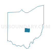
BURLINGTON TOWNSHIP Voting District, Licking County, Ohio
About
Outline

Summary
| Unique Area Identifier | 648580 |
| Name | BURLINGTON TOWNSHIP Voting District |
| County | Licking County |
| State | Ohio |
| Area (square miles) | 25.57 |
| Land Area (square miles) | 25.52 |
| Water Area (square miles) | 0.05 |
| % of Land Area | 99.81 |
| % of Water Area | 0.19 |
| Latitude of the Internal Point | 40.22442900 |
| Longtitude of the Internal Point | -82.51536120 |
Maps


Graphs
Select a template below for downloading or customizing gragh for BURLINGTON TOWNSHIP Voting District, Licking County, Ohio


Neighbors
Neighoring Voting District (by Name) Neighboring Voting District on the Map
- BENNINGTON TOWNSHIP Voting District, Licking County, OH
- LIBERTY TOWNSHIP A Voting District, Licking County, OH
- MCKEAN TOWNSHIP Voting District, Licking County, OH
- MILFORD B Voting District, Knox County, OH
- MILLER Voting District, Knox County, OH
- MORGAN Voting District, Knox County, OH
- WASHINGTON TOWNSHIP Voting District, Licking County, OH
Top 10 Neighboring County Subdivision (by Population) Neighboring County Subdivision on the Map
- Washington township, Licking County, OH (3,109)
- Liberty township, Licking County, OH (2,360)
- Milford township, Knox County, OH (1,772)
- Bennington township, Licking County, OH (1,687)
- McKean township, Licking County, OH (1,523)
- Burlington township, Licking County, OH (1,223)
- Morgan township, Knox County, OH (1,085)
- Miller township, Knox County, OH (1,006)
Top 10 Neighboring Unified School District (by Population) Neighboring Unified School District on the Map
Top 10 Neighboring State Legislative District Lower Chamber (by Population) Neighboring State Legislative District Lower Chamber on the Map
Top 10 Neighboring State Legislative District Upper Chamber (by Population) Neighboring State Legislative District Upper Chamber on the Map
Top 10 Neighboring 111th Congressional District (by Population) Neighboring 111th Congressional District on the Map
Top 10 Neighboring Census Tract (by Population) Neighboring Census Tract on the Map
- Census Tract 7550, Licking County, OH (6,569)
- Census Tract 7547, Licking County, OH (6,552)
- Census Tract 77, Knox County, OH (6,459)
- Census Tract 74, Knox County, OH (5,583)